Engineering Geology for the Snowy Mountains Scheme
This entrenchment is a consequence of the rejuvenation of the streams following the uplift of the area, and is deepest where the streams cut through the fault escarpments or warped zones.
The valleys of the Crackenback River, Upper Snowy River, Geehi River and Bogong Creek have generally straight, almost parallel courses, following along major fault zones. The middle reaches of the Eucumbene river flowing from north to south are generally along the foot of the broadly warped and step-faulted zone forming the eastern margin of the main mountain block; joining the Snowy near Jindabyne the river occupies a rather narrow north-south trough-like depression (the future Jindabyne reservoir) which was formed by down-faulting of a block of country bounded along the west by a north-north-east trending fault, and on the east by north-south faults.
Rock Types and Their Distribution:
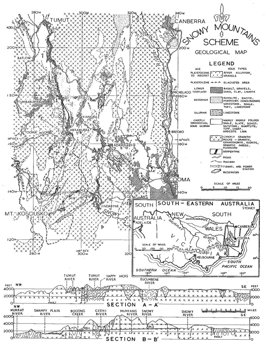
The geology of the Snowy Mountains area, particularly its geological structure, is of considerable complexity. The principal rock types and their distribution are shown in Fig. 1.
The greater part of the area is composed of granitic rocks, consisting of several distinct masses of intrusive granite*, and also granitic gneisses—hard crystalline metamorphic rocks superficially resembling fine-grained granites, but which often show remnants of sedimentary bedding and mineralogical evidence of sedimentary origin.
The remaining part of the area is mainly composed of highly folded, sedimentary and metamorphosed sedimentary rocks which occur often in broad belts trending north-north-east.
These are chiefly of Ordovician Age. For the most part they were originally muds, silts and sands together with some volcanic ash, laid down under marine conditions. These sediments were subsequently compacted, cemented and in some cases recrystallized by deep burial and compression accompanying their folding, and by the granite intrusions. The original muds were converted into hard compact shales and mudstones, or to slates, phyllites and schists; the silts to hard silt-stones; and the sands to hard compact sandstones or to quartzites and quartz schists. In the north-west quadrant of the map there are also cherts, andesitic lava: and hard compact tuffs also of Ordovician age. There are limited areas of strata of Silurian age, chiefly in the north-western quadrant, consisting mainly of shales, slates, phyllites, sandstones and quartzites. These are also highly folded. A belt 4,000 feet wide and 6 miles long of highly cavernous limestone exists in the vicinity of Yarrangobilly, but it does not extend onto the sites of any of the proposed works. Another narrow belt of limestones passes through the lowest portion of the reservoir rim of the proposed Tantangara Reservoir, and represents a possible path for leakage. The precise distribution of the limestone and the extent of its caverns and solution channels are being investigated at present, in order that the likelihood of leakage from the reservoir can be evaluated, and the need or otherwise for treatment to prevent leakage determined. Conglomerates, sandstones, shales, limestone, tuffs and acid lavas of Devonian age overlie the Silurian rocks in the Ravine-Talbingo area along the middle reaches of the Tumut river where the proposed T.5 and T.6 projects are located.
*The term “granite” as used throughout this paper also includes related rock types such as granodiorite and quartz diorite.
